Spain • • Erick Serrano • 🌿 Progressive
Heat wave cut short, but Andalusia workers face 42°C Saturday
Spain's Aemet declared the fourth heat wave of the season over on Friday, one day ahead of schedule, but Andalusia will still see 40-42°C on Saturday before…
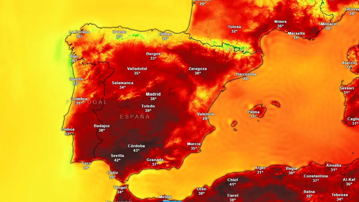
Residents and outdoor workers in Andalusia's Guadalquivir Valley, Genil basin, and Atlantic-facing areas will endure another day of 40 to 42 degrees Celsius this Saturday, even as Spain's State Meteorological Agency (Aemet) announced the early end of the country's fourth heat wave of the season, according to agency spokesperson Rubén del Campo, speaking through official channels.
🔹 What happened: Aemet shortened the heat wave — which started Wednesday — by one day, moving its end from Saturday to Friday, after forecasting an inflow of cool air from the north. That air mass will bring relief to the Cantabrian coast, the upper and middle Ebro, and the northern and central peninsula. Saturday remains hot in southern Atlantic zones with highs of 40-42°C. Starting Sunday midday, a western trough will push cooler air first into the southwestern quadrant and by Monday across the full peninsula and Balearic Islands. Del Campo warned that storms with hail and strong wind gusts are expected in the Pyrenees and eastern interior areas. The Canary Islands will see no improvement, with calima and climbing temperatures instead.
🔹 Why it matters: For people working outdoors in Andalusia — including agricultural laborers in the Guadalquivir and Genil regions — Saturday brings no relief despite the official end of the heat wave designation. Overnight temperatures in the Mediterranean coast and inland Andalusia will not drop below 25 degrees Celsius in some locations, compressing recovery time before the next workday. Mountain communities in the east face a different threat: hail and intense wind from the forecast storms. Canary Islands residents are excluded from the nationwide cooling pattern entirely, facing continued heat and calima conditions with no timeline for change given in the source.
📌 EPM Take: Four heat waves in one season, and the fourth lasted two days before Aemet clipped it early. The headline says relief — but the details say Saturday in Andalusia still hits 42 degrees, Sunday rebounds to 38 across the east and Mallorca, and some Mediterranean and inland Andalusian communities won't dip below 25 overnight. Del Campo said that plainly. What that means in practice for someone doing physical labor on Saturday morning in the Guadalquivir Valley is not in any forecast graphic. EPM has covered the strain on Spain's emergency and social infrastructure repeatedly this summer. The meteorological pattern here adds one more layer: if a fifth wave follows — and nothing in the source rules it out — it arrives against a population and a response system that has been through this four times already this season, with Canarias having never gotten a break.
Ola de calor acortada pero Andalucía soporta 42 grados más días
La Aemet adelantó el fin de la cuarta ola de calor al viernes, pero Andalucía seguirá con 40-42 grados el sábado y Canarias no recibirá alivio.
Mientras la Aemet anuncia el fin anticipado de la cuarta ola de calor de la temporada, los habitantes del Valle del Guadalquivir, la cuenca del Genil y la vertiente atlántica de Andalucía seguirán expuestos a temperaturas de entre 40 y 42 grados este sábado, según informó el portavoz del organismo, Rubén del Campo, a través del sitio web oficial de la Agencia Estatal de Meteorología.
🔹 Lo que pasó: La Aemet redujo en un día la duración de la ola de calor —de sábado a viernes— tras anticipar la llegada de una masa de aire fresco desde el norte. Esta masa afectará al Cantábrico, el alto y medio Ebro, y el norte y centro peninsular el viernes mismo. El domingo, una vaguada occidental iniciará un descenso térmico más amplio, primero en el cuadrante suroccidental y el lunes en toda la península y Baleares. Las madrugadas en el Mediterráneo y el interior de Andalucía no bajarán de 25 grados en algunos puntos. Canarias queda excluida de cualquier mejora, con calima y temperaturas en ascenso.
🔹 Por qué importa: Las personas que trabajan al aire libre en Andalucía, agricultores y jornaleros del Guadalquivir entre ellos, enfrentan un sábado con máximas de 40 a 42 grados sin que el alivio llegue a sus zonas. Las tormentas previstas en los Pirineos y el interior oriental, con granizo y viento intenso según Del Campo, representan otro tipo de riesgo para comunidades de montaña. Canarias, sin acceso al aire fresco que recorrerá la península, verá un patrón climático divergente que agrava la exposición prolongada al calor para sus residentes. El lunes será el primer día en que el grueso de la población peninsular y balear podrá esperar temperaturas acordes a la época.
📌 Conclusión EPM: Cuatro olas de calor en una temporada y la más reciente apenas duró dos días completos antes del corte: el patrón habla por sí solo. Pero el alivio del viernes no llega parejo. Mientras el norte respira, la cuenca del Guadalquivir acumula otro día de 40-42 grados, y Canarias no entra en ninguna ecuación de mejora. Rubén del Campo advirtió que las madrugadas mediterráneas y del interior andaluz no bajarán de 25 grados. Eso no es una estadística abstracta: es la temperatura mínima a la que descansa —o no descansa— quien trabaja al día siguiente en el campo. La pregunta que el parte meteorológico no responde es cuántos ciclos consecutivos de calor extremo puede absorber una población trabajadora antes de que el sistema de salud empiece a acusar el acumulado.
¿Te gustó este artículo? Recibe cobertura global en tu correo.
Suscríbete gratis / Subscribe free