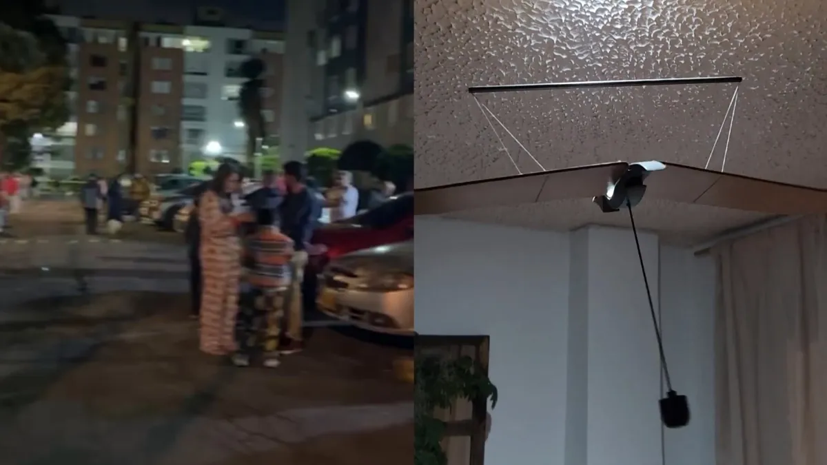
Vecinos evacuados de noche en un conjunto residencial y una lámpara oscilando dentro de una vivienda durante el sismo de la madrugada. · El Tiempo
Magnitude 5.6 earthquake in Colombia: evacuations in Bogotá, Pereira and Chaparral
An earthquake of magnitude 5.6 shook Colombia at 04:13 on Tuesday, November 3, 2026, according to the preliminary bulletin of the Colombian Geological Service.
A 5.6 earthquake shook Colombia before dawn and forced building evacuations
The Colombian Geological Service recorded an earthquake of magnitude 5.6 at 04:13 on Tuesday, with its epicenter located 17 kilometers from Roncesvalles, in…
An earthquake of magnitude 5.6 was recorded in Colombia on Tuesday, November 3, 2026, at 04:13 local time, according to the preliminary bulletin issued by the Colombian Geological Service. Some people recorded the moments of panic, and others described how the evacuation unfolded in their cities.
--- The context ---
The tremor was felt in Chaparral, in Tolima, identified in residents' reports as the site of the epicenter, and also in Bogotá and Pereira. The residents' own videos became the first account of the early morning hours.
--- The facts ---
According to the official report from the seismological agency, the exact epicenter was located 17 kilometers from the municipality of Roncesvalles, in Tolima. The technical analysis placed the event at latitude 3.86 and longitude -75.63, in an area of the country's Andean region.
--- The positions ---
The only official voice carried in the source is the Colombian Geological Service, author of the preliminary bulletin with the magnitude, the time and the location. The remaining accounts come from those who felt the quake and shared recordings and evacuation stories.
--- What remains unknown ---
The cited bulletin is preliminary, and the measurement may be adjusted in later reports. The source includes no tally of damage or affected people: what is confirmed is limited to the magnitude, the time, the epicenter and the coordinates.
--- Unanswered questions ---
Will the magnitude be adjusted in the Geological Service's definitive bulletin? What evacuation reports will arrive from the cities where the quake was felt most strongly? Will local authorities confirm the condition of the areas near the epicenter?
--- EPM analysis ---
The citizens' record arrived together with the technical data: the panic videos and evacuation accounts circulated while the seismological agency fixed the magnitude, the time and the exact epicenter point in Tolima.
📌 EPM Take: In EPM's view, the early morning left a clear lesson: when an earthquake strikes, verified information is worth as much as a fast reaction. The Colombian Geological Service precisely fixed the magnitude, the time and the epicenter, and citizens provided the images of the evacuations in Bogotá, Pereira and Chaparral. That combination of official data and direct testimony is what makes it possible to understand what happened without rumors or exaggeration.
Colombia woke up on Tuesday, November 3, 2026, to an earthquake of magnitude 5.6 recorded at 04:13 local time, according to the preliminary bulletin of the Colombian Geological Service. The shaking was felt in Chaparral, Bogotá and Pereira, and led to evacuations in different cities.
--- The context ---
Residents' reports placed the epicenter in Chaparral, in the department of Tolima. Amid the tremor, some recorded the moments of panic, and those who left their homes described how the evacuation developed in each city.
--- The facts ---
The seismological agency's official report then specified the exact point: 17 kilometers from the municipality of Roncesvalles, Tolima. The technical analysis situated the event at latitude 3.86 and longitude -75.63, within the country's Andean region.
--- The positions ---
The Colombian Geological Service provided the official information on the event in its preliminary bulletin: magnitude, time and location. On the citizens' side, the testimonies and recordings shared from the cities where the quake was felt completed the picture of the early morning.
--- What remains unknown ---
Because the bulletin is preliminary, the data may be refined by the agency in subsequent measurements. The source reports no official tally of consequences: what is established is the technical record of the shaking and the evacuation accounts gathered in the cities.
--- Unanswered questions ---
Will the definitive bulletin keep the magnitude of 5.6 and the epicenter located near Roncesvalles? What will local reports say from the rural areas of Tolima close to the epicenter? Will the authorities in Bogotá and Pereira address the recorded evacuations?
--- EPM analysis ---
When the epicenter is located with precise coordinates and at a measured distance from a specific municipality, public discussion can focus on the facts: what was felt, where people evacuated and what the official measurement confirms.
📌 EPM Take: In EPM's view, this early morning's report rests on measurable data: magnitude of 5.6, exact time, an epicenter located 17 kilometers from Roncesvalles and coordinates published by the seismological agency. With that technical record, and with the evacuation testimonies in Bogotá, Pereira and Chaparral, the country can assess what happened calmly and with no room for inflated versions.
Sismo de magnitud 5,6 en Colombia: evacuaciones en Bogotá, Pereira y Chaparral
Un sismo de magnitud 5,6 sacudió a Colombia a las 04:13 de este martes 3 de noviembre de 2026, según el boletín preliminar del Servicio Geológico Colombiano.
Un sismo de 5,6 sacudió a Colombia de madrugada y obligó a evacuar edificios
El Servicio Geológico Colombiano registró un sismo de magnitud 5,6 a las 04:13 de este martes, con epicentro localizado a 17 kilómetros de Roncesvalles, en el…
Un sismo de magnitud 5,6 se registró en Colombia este martes 3 de noviembre de 2026 a las 04:13 hora local, según el boletín preliminar emitido por el Servicio Geológico Colombiano. Algunas personas grabaron los momentos de pánico y otras contaron cómo fue la evacuación en sus ciudades.
--- El contexto ---
El temblor se sintió en Chaparral, en el Tolima, señalado en los reportes de los ciudadanos como el punto del epicentro, y también en Bogotá y en Pereira. Los videos de los propios habitantes fueron el primer registro de la madrugada.
--- Los hechos ---
De acuerdo con el reporte oficial de la entidad sismológica, el epicentro exacto fue localizado a 17 kilómetros del municipio de Roncesvalles, en el Tolima. El análisis técnico ubicó el evento en las coordenadas de latitud 3,86 y longitud -75,63, en una zona de la región andina del país.
--- Las posiciones ---
La única voz oficial recogida en la fuente es la del Servicio Geológico Colombiano, autor del boletín preliminar con la magnitud, la hora y la localización. Los demás testimonios son de quienes sintieron el sismo y compartieron grabaciones y relatos de evacuación.
--- Lo que falta saber ---
El boletín citado es preliminar, y la medición puede ser ajustada en reportes posteriores. La fuente no incluye balances de daños ni de afectados: lo confirmado se limita a la magnitud, la hora, el epicentro y las coordenadas.
--- Preguntas sin respuesta ---
¿Se ajustará la magnitud en el boletín definitivo del Servicio Geológico Colombiano? ¿Qué reportes de evacuación llegarán desde las ciudades donde el sismo se sintió con más fuerza? ¿Confirmarán las autoridades locales el estado de las zonas cercanas al epicentro?
--- Análisis EPM ---
El registro ciudadano llegó junto con el dato técnico: videos y relatos de evacuación circularon mientras la entidad fijaba magnitud, hora y epicentro en el Tolima.
📌 Conclusion EPM: A juicio de EPM, la madrugada dejó una lección clara: frente a un sismo, la información verificada vale tanto como la reacción rápida. El Servicio Geológico Colombiano fijó con precisión la magnitud, la hora y el epicentro, y los ciudadanos aportaron las imágenes de las evacuaciones en Bogotá, Pereira y Chaparral. Esa combinación de dato oficial y testimonio directo es la que permite entender lo ocurrido sin rumores ni exageraciones.
Colombia amaneció este martes 3 de noviembre de 2026 con un sismo de magnitud 5,6 registrado a las 04:13 hora local, según el boletín preliminar del Servicio Geológico Colombiano. El movimiento se sintió en Chaparral, Bogotá y Pereira, y obligó a evacuar en distintas ciudades.
--- El contexto ---
Los reportes de los habitantes ubicaron el epicentro en Chaparral, en el departamento del Tolima. En medio del temblor hubo quienes grabaron los momentos de pánico, y quienes salieron de sus viviendas fueron contando cómo se desarrolló la evacuación en cada ciudad.
--- Los hechos ---
El reporte oficial de la entidad sismológica precisó después el punto exacto: a 17 kilómetros del municipio de Roncesvalles, Tolima. El análisis técnico situó el evento en la latitud 3,86 y la longitud -75,63, dentro de la región andina del país.
--- Las posiciones ---
El Servicio Geológico Colombiano sostuvo la información oficial del evento en su boletín preliminar: magnitud, hora y localización. Del lado ciudadano, los testimonios y las grabaciones difundidas desde las ciudades donde se sintió el sismo completaron el panorama de la madrugada.
--- Lo que falta saber ---
Por tratarse de un boletín preliminar, los datos pueden ser refinados por la entidad en mediciones siguientes. La fuente no reporta un balance oficial de consecuencias: lo establecido es el registro técnico del movimiento y los relatos de evacuación recogidos en las ciudades.
--- Preguntas sin respuesta ---
¿Mantendrá el boletín definitivo la magnitud de 5,6 y el epicentro localizado cerca de Roncesvalles? ¿Qué dirán los reportes locales de las zonas rurales del Tolima cercanas al epicentro? ¿Se pronunciarán las autoridades de Bogotá y Pereira sobre las evacuaciones registradas?
--- Análisis EPM ---
Cuando el epicentro queda localizado con coordenadas precisas y a una distancia medida de un municipio concreto, la discusión pública puede concentrarse en los hechos: qué se sintió, dónde se evacuó y qué confirma la medición oficial.
📌 Conclusion EPM: A juicio de EPM, el parte de esta madrugada se sostiene en datos medibles: magnitud de 5,6, hora exacta, epicentro localizado a 17 kilómetros de Roncesvalles y coordenadas publicadas por la entidad sismológica. Con ese registro técnico, y con los testimonios de evacuación en Bogotá, Pereira y Chaparral, el país puede evaluar lo ocurrido con serenidad y sin espacio para versiones infladas.